
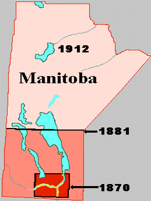
The red square at the bottom of the map shows the size of Manitoba 1870-1881. New Iceland 1875-1881 was thus outside the Manitoba boundaries. In 1881 Manitoba boundaries were moved east, north and west. New Iceland then became a reserve in Manitoba. In 1912 the boundaries were moved north to the present position.
Province of Manitoba: Manitoba is located in southern Canada, between Saskatchewan and Ontario, on the US border adjacent to North Dakota and Minnesota. The southern Manitoba landscape is governed by granites and related rocks over two billion years old along the Ontario border, half-billion-year-old flat limestones to the west in the Interlake region between the major lakes of Lake Winnipeg and Lake Manitoba, and in western Manitoba, travelers heading west from Winnipeg climb up a steep escarpment onto a thick layer of shale. Climate is hot and moist in the summer, and snowy and very cold in the winter. Agriculture is not possible on most of the sandy and rocky soils of the rough landscape east of Lake Winnipeg. Over the limestones around Lake Manitoba and Lake Winnipeg, glaciers of the Ice Age abraded the rock, and produced silty soils rich in limestone. In the Red River Valley south of Lake Winnipeg, a large lake called Lake Agassiz formed 10,000 years ago, as the Ice Age glacier retreated. Flat clay-rich soils were deposited in the lake in this area, around the city of Winnipeg. On the shale of southwestern Manitoba, rolling grassy hills occur, in an area that was above the stony, limestone rich soils of the Interlake, and the clay of the Red River Valley.
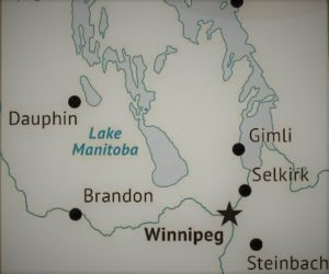
Map shows southern Manitoba. Gimli is on the western bank of Lake Winnipeg. The Interlake region is the area between Lake Winnipeg and Lake Manitoba in the west.
Interlake: In southern Manitoba, Lakes Manitoba and Winnipeg occur on flat limestones north of Winnipeg. The 100-km-wide area between them is called the Interlake. Soils are thin over bedrock, and glaciers of the Ice Age produced stony soils rich in limestone. Icelandic people settled across the Interlake, in towns such as Arborg and Lundar, as well in areas west of Lake Manitoba such as Langruth. In this area, summers are moist, and winters are snowy and very cold. Agriculture is possible but challenging on this poorly drained, stony, flat to gently rolling land.
Manitoba, southwestern: Southwestern Manitoba lies above a thick layer of shale that extends with related rocks from Brandon, Manitoba to Calgary, Alberta. This layer of shale caused southwestern Manitoba to be above the stony, limestone rich soils of the Interlake, and the clay of the Red River Valley. As a result, the landscape consists of rolling grassy hills, in an area where the soils are well drained and very favourable for agriculture. Icelanders settled in this area, mainly in the Argyle settlement around the communities of Baldur, Grund, Bru, and Glenboro. This area includes the Tiger Hills, and other gently rolling hills, most of which formed as moraines at the edge of the retreating continental Ice Age glacier. (Text: Dr. Harvey Thorleifson, University of Minnesota. Translator: JÞ. Icelandic editor: Dr. Áslaug Geirsdóttir, Háskóli Íslands)