
Icelandic Settlement:
The land between Lake Winnipeg to the east and Lake Manitoba – Lake Winnipegosis to the west is called the Interlake District. It is about 415 km (258 miles) long from north to south and the width ranges from 64 km to 160 km (40 to 100 miles). The soil is mostly sandy clay, and the rich black soil, which characterizes the plain in the southern part of the province, is found only in a few places in the district.
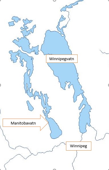
There are four major lakes in Manitoba. Lake Manitoba is the largest, but west of it are three smaller lakes. To the south is Lake Manitoba, then Lake Winnipegosis and to the north Lake Cedar
In the first years of settlement in the 1870s, it was said that the Interlake area had mostly been forested, but between the forest belts there were areas with meadows and small ponds. As you got close to the lakes, both east and west, meadows, bays and swamps took over. The whole district is mostly flat, but in some areas, there are small ridges and rises. In the middle of the district, however, the soil is very rocky. Almost the entire district is therefore much worse suited to agriculture than the plains. The forest was mostly poplar, but spruce is quite prominent in the northeastern part. Among the poplar trees grew oak, birch, elm and maple.
Icelanders were the first whites to explore lands in the district, with a few of them settling on the west bank of Lake Winnipeg in 1875. There were some halfbreeds there, but their fate was difficult because the natives did not care for them on their reserves and they had a hard time making a living in urban areas like Winnipeg, Brandon or Selkirk.
Icelanders were also the first to study land in the western part of the area, east of Lake Manitoba. A few French, Scots, and Metis had actually settled here and there but no settlement had formed. It was in 1886 that Icelanders in Winnipeg began to pay attention to reports on available land along southeastern Lake Manitoba. A few went on an expedition during the summer and Frímann B. Anderson led the group. They found, in many places, appealing areas where grass grew well between the forest belts and it was ideal for raising animals, especially sheep farming. Another thing that pushed Icelanders was the rumor that a railway would be built from Winnipeg north through the western part of the Interlake to Hudson Bay. It was therefore natural that Icelanders decided in the autumn of 1886 to look for their future north along the east shore of Lake Manitoba.
On May 24, 1887, a small group of Icelanders traveled to Shoal Lake (Grunnavatn), where Frímann Anderson and his friends had visited. They liked it, so there by the lake began a new settlement of Icelanders in western Canada. The settlement that was formed there was called the Shoal Lake Settlement (Grunnavatnsbyggð).
The flow of immigrants from Europe west to the Canadian plains was great, and gradually the plains in southern Manitoba were taken and many sought lands along Lake Manitoba, both east and west. These were mainly settlers who were interested in fishing as well as animal husbandry. Such an area fascinated many Icelanders in the last decade of the 19th century.
Two settlements formed east of the lake, Shoal Lake Settlement (Grunnavatnsbyggð) and Swan Lake Settlement (Álftavatnsbyggð). In the middle of the 20th century, people in the west began to call them by one name, Lundarbyggð (Lundar Settlement), because the town of Lundar was the heart of these settlements. Another town, considerably smaller formed further south on the lake and is called Oak Point.
English version by Thor group.